FORGOTTEN IRELAND
by Patrick Whitehurst, Ireland Editor
There is a charm about Southwest Cork that defies description, an intangible magic in the wild countryside that dips and twists between mountains and the sea, between rocky barrenness and lush greenness. 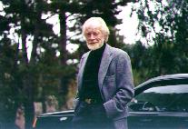
Patrick Whitehurst in an Irish mood.
There are deep harbors and hidden coves, sweeping golden beaches and steep cliffs that drop precipitously into the sea. And everywhere there is riotous color; hand-painted shopfronts, vividly painted houses, and wild roses that bloom until late October.
In the summer months wild fuchsia hedges dangle delicate crimson ballerinas over the roads. Hedges heavy with wild cherries, sloes, damsons, and strawberries line the byways and in the fall and winter months the russet gold of winter bracken and the soft amethyst of heather and the bright yellow of gorse burnish the hills, and always, as the late Seán Ó Faoláin observed there is always "the cup of blue sea on the horizon."
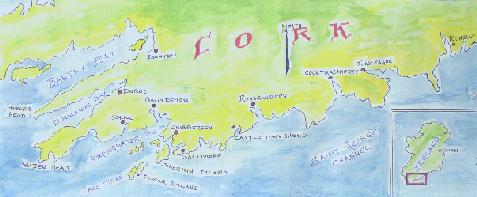
The "Forgotten Ireland."
MAP BY AUTHOR
It is easy to fall in love with this place ... it is a hard place to leave. This is the "Forgotten Ireland" I once called home.
That this region of Ireland is "forgotten" means only that it is almost never on a "must see" itinerary when one plans their first trip to Ireland, but it is one of the favored parts for the native Irish and those of us who have discovered its beauty and tranquillity. Members of the Irish Parliament and government have permanent summer and holiday homes in the area; famous people from around the world seek out its serenity, its sense of ancient history, its hideaway beaches, its superb river, lake and deep-sea fishing, its comfortable pubs and some of the finest cuisine and accommodations in the British Isles and western Europe.
The huge tour buses avoid the area like the plague because of the narrow winding roads. And we are thankful for this because it saves us from invasion by hundreds of tourists disgorging from diesel belching, puce-colored road behemoths.
Consider Kinsale just 18 miles south of Cork City. It is the gateway to this magic land of Southwest Ireland. It is small, it is ancient, and it is steeped in history and tragedy, but today it is a happy place and has some of the best restaurants in Europe and a reputation for being the culinary capital of Ireland.
Kinsale can get under your skin and make you linger. You forget where it was that you were so anxious to go next, and when you return home it will tug at your memory and make you dream about owning one of those bow-windowed houses that line its meandering crooked streets overlooking the harbor.
Kinsale has been invaded by Romans, by Spaniards, and by the English in its past, but today it is invaded from the sea by expensive yachts that are drawn into Kinsale's perfect harbor.
A day of deep-sea fishing off the Old Head of Kinsale might slow you down for a day. Exploring James Fort build in 1601, or Charles Fort begun in 1677 might delay you for another day, but then you get an opportunity to try one of the more lively pubs noted for their music, entertainment, and seafood pub-grub before you travel on.
Like misshapen fingers pointing westward toward the sea, the peninsulas of Southwest Cork are only half discovered. From Kinsale Harbor to the headlands of the Sheeps Head peninsula the world seems to have stepped back in time. The warm waters of the Gulf Stream wash this coast and create an environment unique at this high latitude. Palm trees and lush exotic plants are enlivened by the ever-changing sky and wash the land with a pallet of color, sometimes vivid, sometimes muted in mist. Picture-book villages and quiet lakes take you back to the fairy-tale books of childhood, and the quiet thunders in your ears.
This is wildly beautiful country where the Atlantic coastline is almost always in sight and dolphins leap and dance on their tails just offshore. The village names, at first strange sounding to ears not yet attuned to Irish derivations, begin to sing in rare melody - Ballydehob, Skibbereen, Clonakilty. It is a place where every stranger is a friend. Irish Gaelic is heard in the shops and pubs because this is part of the West Cork Gaeltacht, or Gaelic-speaking area.
The village roads are lined shoulder to shoulder with Georgian facades and Gothic abbeys with farmland unfolding immediately behind the garden walls. And history sits on your shoulders. In Timoleague there are the ruins of a 14th century Franciscan friary. They are spectacular. Curved stone staircases lead upward to a roofless circular opening and the sky.
The twisting road that follows the bay passes the village of Courtmacsherry, which feels like the end of the world and everywhere there are kingfishers, cormorants, and swans. In Courtmacsherry, every house faces the sea. Past Courtmacsherry following the sea, Inchydoney Island (not really an island anymore) offers miles of soft sand swirling in a beautiful curve around the promontory ... a wonderful place for a swim and a beach picnic.
Antiquity abounds in this area and there is joy in the freedom to search for and discover these treasures of history, alone, without a guide or a park guard watching over your shoulder. Near Rosscarbery one can unroll the picnic blanket within one of the two fine stone circles where four millennia ago ancients assembled.
Farther along the road, just outside Castletownshend is a line of ancient-standing stones, one of them missing because Madam Townshend of the Castle, having no respect for Irish antiquity, wanted it for her rockery. The stones are known as the Fingers. They are strange and breathtaking in their unexpectedness. They are like three stern priests of some long forgotten religion. They evoke the past as powerfully as the Egyptian pyramids and Incan ruins.
The natural hub of the region is Skibbereen. More than a village, it is the bustling commercial center of the area, with the spokes of roads radiating from it toward the villages of Roaring Water Bay; Baltimore and Ballydehob and Schull, past Durrus and into Bantry.
The ruined castle of the infamous 17th century O'Driscoll pirates looms behind the harbor at Baltimore and near the pier you will see a sign directing you to Miss Josephine, the ferry to Sherkin Island. It is only a 10 minute ferry ride from Baltimore to tiny Sherkin Island, where the unsurpassed Sherkin Island sweaters are woven, the populance is mostly cows, and the stone remains of a Franciscan friary sits desolately among low rolling hills. A 10 minute ferry ride, but a 100 year step back into the past.
The highest mountain in the area, Mt. Gabriel, sweeps into Roaringwater Bay at Schull. Schull is a vibrant village that revolves around a single steep hill with shops and restaurants beckoning from flagstone byways. Its harbor dances with fishing boats returning from the sea. If after a day on Clear Island or an afternoon exploring along the 700-foot cliffs of the Mizen Head you are looking for the amenities of civilization, you could do no better than the Courtyard in the center of town. 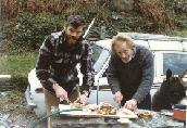
The author gets a little help with scallop cleaning. The critter's optional.
Just before Bantry, the village of Durrus sits at the head of Dunmanus Bay. Many maps do not even indicate the road that follows the coasts around the Sheepshead peninsula. Immediately from the road tracing its route along the north shore of Dunmanus Bay from Durrus to Ahakista and to Kilcrohane the road climbs a steep and twisting borheen called the Goats Path.
The mountain is called Pekeen and at its peek is a statue facing the winds, its arms raised as if blessing the glory of the fields below, the mountains around it, and the two bays it surveys from its high vantage point: Dunmanus Bay to the south, Bantry Bay to the North. From here the world below seems to be made on a smaller scale: the fields are mere paddocks, so reduced from this height they appear a patchwork of quilters' greens, separated by a stitchery of gray stone walls.
In the mountains around, where roads cannot go, wild goats like shaggy white dancers on the steep cliffs, appear as ghosts that cannot be captured. The fox and the badger slink along the base of stone walls at twilight and in the early dawn; other shadow ghosts of this wild peninsula. This is the part of West Cork that was my home.
The whole peninsula is cloaked in gently ambiance. The roads are seldom crowded except when you come upon a herd of black and white milk cows being moved from one pasture to another, or when, on a Sunday afternoon you encounter a host of men road-bowling between Ahakista and Kilcrohane. The mountains above the road are uninhabited and the views of Bantry Bay from their peeks are spectacular.
Fishing port, market town, tourist center and passageway to Ireland's mountainous county Kerry, Bantry town sits at the head of Bantry Bay. Bantry is an ideal base to explore the Beara peninsula. The area around Bantry is lush country with wide beaches, and remote lakes and rivers. It is perfect for more athletic pursuits, from walking to skin diving, and from horse riding to golf. And for the more adventurous there is hang-gliding and para-gliding.
The road beyond Bantry and through Ballylicky is more well-traveled and the adventures ahead are the stuff that dreams are made of: the Ring of Kerry, the Lakes of Kilarney, and the Dingle Peninsula.
But the road behind is the one that will haunt your memories ... and you will return.